Wednesday, January 16, 2013

Beijing's Air Quality Is Way Unsafe

A big area of research that I'm working on is air quality.  Recently I was browsing the web and saw a New York Times article stating that the quality of air for Beijing, China reached 755. That's 20 times over what is deemed safe. The EPA says the levels between 301 and 500 are “hazardous” and outdoor activity should be avoided. This is alarming that Beijing’s air quality is so high. In fact, in 2012 the American Lung Association State of the Air report stated that though there is an improvement in air quality in many places, “over 127 million people—41 percent of the nation—still suffer pollution levels that are too often dangerous to breathe.” Air is what we need to survive and if the air is polluted, many people can get sick or die.

According to the article, Beijing’s embassy's Twitter called the reading “crazy bad” and that terminology was used back in November 2010. It was quickly deleted off the Twitter feed then. NASA released images of Beijing, taken by the Moderate Resolution Imaging Spectroradiometer (MODIS) on NASA’s Terra satellite, on January 3 and January 14, 2013.

 January 3

 January 14

You can see the difference between the two days with significantly less visibility appearing on the latter date. This is really bad. People should not have to wear masks or like one man in the article said; he had air purifiers running at full power.

Much of the pollution is caused by particulate matter (PM) which is trapped in the air. This particulate matter can be caused by factories, cars and biomass burning, though the structure of the region can have effect on the air quality as well. Much of the particulate matter that is measured is PM 2.5. PM 2.5 refers to the diameter of matter itself is 2.5 microns or smaller. Here is a graph showing the comparison of PM 2.5 to a human hair.


PM 2.5 might seem small but this matter can get into the lungs and cause respiratory problems such as asthma, bronchitis, pneumonia, emphysema and other health problems. The matter can also contribute to premature deaths. In fact one article states that, "Hospitals have also reportedly admitted 20 to 30 percent more patients, who complained of respiratory issues that were likely caused by breathing heavily polluted air." Talk about visibility too. With that much particles hanging in the atmosphere, visibility can be little to none, which makes it hard for transportation like buses and planes. Here is a comparison of Beijing's skyline. The top is from August 29, 2010 and the bottom is January 14, 2013.


 According to the article, “Xinhua, the state news agency, reported on Dec. 31 that Beijing’s air quality had improved for 14 years straight, and the level of major pollutants had decreased. A municipal government spokesman told Xinhua that the annual average concentration of PM 10, or particles 10 microns in diameter or smaller, had dropped by 4 percent in 2012, compared with one year earlier.” Through this statement and actuality however, something should really be done about Beijing’s air, as the pollution is a big danger for the people who live there. The article states there is an outcry for more data about the PM 2.5 levels in the area. The PM 2.5 data should be released as it can be more deadly.

Wednesday, December 5, 2012

Change To Hurricane Warning System

Today the National Hurricane Center (NHC) issued a statement to begin before the start of the 2013 hurricane season, that changes the criteria for issuing hurricane warnings. These changes are to include hybrid/transitioning storms like Hurricane Sandy.

This is the new definition:
"An announcement that sustained winds of 74 mph or higher are expected somewhere within the specified area in association with a tropical, sub-tropical, or post-tropical cyclone. Because hurricane preparedness activities become difficult once winds reach tropical storm force, the warning is issued 36 hours in advance of the anticipated onset of tropical-storm-force winds. The warning can remain in effect when dangerously high water or a combination of dangerously high water and waves continue, even though winds may be less than hurricane force."
According to The Weather Channel:
"The changes come on the heels of an investigation into Hurricane Sandy, which became a post-tropical storm before making landfall in the Northeast. Tropical storm and hurricane warnings were not issued anywhere on the East Coast north of North Carolina, and a NOAA and FEMA investigation is underway to study the handling of the events surrounding Sandy, which is a customary occurrence for major weather events..."

Previously the hurricane warning definition was:

"An announcement that hurricane conditions are expected within the specified area.
Because outside preparedness activities become difficult once winds reach tropical storm force, warnings are issued 36 hours in advance of the anticipated onset of tropical-storm-force winds."

Tuesday, December 4, 2012

NASA Social with Astronaut Joe Acaba


 Today was the NASA Social @NASASocial (previously NASA Tweetup) event with astronaut Joe Acaba @AstroAcaba, at NASA Headquarters in DC. I went with my husband. This is our third NASA Social. We were a tad bit late for this event. DC traffic got to us, not to mention I'm 39 weeks and 3 days pregnant. Even looking at the clock reading 9:58 am and knowing the event would start promptly at 10:00am, we were determined to get there.

When we finally got to the headquarters and sat quietly in the back and were able to catch some of Mr. Acaba's presentation about his four months aboard the International Space Station (ISS). From the NASA event website,"Acaba launched to the International Space Station on a Russian Soyuz spacecraft May 15. He spent 123 days aboard the orbiting laboratory as a flight engineer of the Expedition 31 and 32 crews. He returned to Earth Sept. 17 after four months off the planet."

After the presentation, the floor was opened for questions and answers, and many of the attendees asked great questions. Mr. Acaba spent most of his time in the copula. He was the sole US crew member aboard the craft, with two Russians cosmonauts. He said his Russian isn't that good. In the presentation we saw that there was exercising aboard the ISS, which he would do in his free time. He talked about working the robotic arm and supporting two of his crewmates during their space walk. He worked on scientific research experiments and preformed maintenance aboard the ISS.  He also gave insight into skills for becoming an astronaut. He said that we are all scientists if we have asked a question and the mission involved improvising, as planning for things to work a certain way, don't always go that way and studying hard. Mr. Acaba also spoke about working on a car and working using your hands. He also said he is not a fault if we take apart our parents car.

He was very informative and had a great sense of humor. He spoke about losing his spoon on the first day and that things float away. Upon his return to Earth he mentioned that it was hard to walk for the first week (gotta love gravity) and that the astronauts plan to land on the ground but they do partake in water survival training. Mr. Acaba made many points about the future of the space program, in one instance he said, "We are looking at going further than we've ever been." He included that he sees in the future, we'll be walking on Mars and living there.

@MsLinda22 asked Mr. Acaba a question from one of her twitter followers about seeing the effects of climate change from space. My ears perked up when I heard that question. His response was that we are not seeing climate change in real time, but comparing pictures from space taken from the ISS years ago to now, do show that the Earth is warming. "It's easy to see from space where everything is interconnected," he stated.  Mr. Acaba also answer questions in Spanish.

The goodie bag included a paper NASA Smallsat, which you can cut out and transform to make it into a cube. We also received an autographed portrait of Mr. Acaba, an information bookmark, a little booklet about space, a NASA sticker, a sticker of the Expedition 32 Patch and a pin of the same expedition. Like I said before, this is our third NASA social event. The ones we attended have all been at the NASA Headquarters in DC. In the near future we hope to attend the social events at other locations like Florida, Virginia and possibly California. I enjoy the events because they give you a behind the scenes look at some of the operations at NASA and allows you to connect with astronauts and people who have the same interest as you. We also hope to participate in more after the Social meetups. If you'd like to catch this event, NASA has the recording on their Youtube page.

For more about the NASA Social events, check out this link.
For more about Astronaut Joe Acaba, click here.

These are my other NASA Social blog entries.
STS-135 in DC
Astronaut Ron Garan

 During the Presentation.

The lights are on!

 Astronaut Joe Acaba.

 Me and my big belly.

 :-)

Thanks to @NASASocial and all who makes these events possible. Had a wonderful time!


***UPDATE*** I had my beautiful baby girl Dec 13!!!! She's into astronomy and knew she wanted to come during the Geminid meteor shower ;-)

Sunday, October 28, 2012

Hurricane Sandy Is Coming

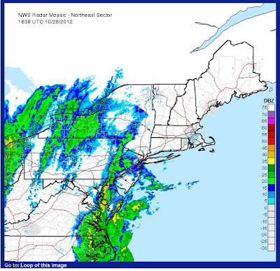
Hurricane Sandy, the 18th named tropical storm of the 2012 Atlantic Hurricane Season, is currently moving slowly up the Mid-Atlantic coast and with recent model tracks, landfall looks to be in central or southern New Jersey. The hurricane is a category one hurricane with max sustained winds at 75 mph, with gusts at 90 mph. The pressure is 952 mb and there is still 36 hours to landfall.

Hurricane Sandy has caused 41 deaths in the Caribbean. Strong winds and heavy downpours are currently over the Carolinas, and the force winds of the storm extend up to 700 miles from the center, while hurricane force wind extend up to 105 miles. Models have the storm turning towards the northwest early Tuesday. There is a high pressure system to the east and the clockwise flow of the high pressure will send Hurricane Sandy back west. Forecasters are calling the events set to occur near Halloween "Frankenstorm." As Sandy moves northwest, there is a stationary front approaching from the west, which will stall the storm and moisture associated with the front will combine with that of Sandy. When this happens Sandy will become an extratropical storm. This is because the core of Sandy with change from warm to cold, due to the merging with an Arctic Jet System.

Forecasters are calling for high storm surges along the Mid-Atlantic as well as heavy rainfall and strong winds. South Jersey, DC, Maryland and NYC are expected to receive around 5 to10" of rain. 8 states along the Mid-Atlantic have issued a state of emergency and Major Micheal Bloomberg has issued coastal evacuations in NYC as well as Governor Chris Christie in New Jersey. Over 12" of snow is also expected to fall in the higher elevations of Southwest Virginia and West Virgina.

Many residents are stocking up on food supplies, ahead of the storm. We are ready for the storm in my apartment! The electric companies are getting ready for downed trees and some areas may be out of power for a week.

Here is the current track of Hurricane Sandy:

Here is the visible satellite image:

The water vapor:

Radar:


 Active Alerts:
 
 
Sandy's Wind Field

Saturday, July 28, 2012

Circuhorizontal Arc In Scotland

 
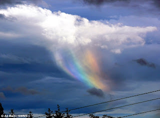
I was browsing the news the other day and saw an article by the DailyMail, showing a beautiful Circuhorizontal arc or 'fire rainbow' in the sky. The photo was taken by Ali Bain and the article states that the phenomena lasted only 20 seconds, before it disappeared. Thank goodness Mr. Bain had his camera handy. Such wonderful creations surely should be captured on film. 

Despite it's name, the phenomena is not produced by fire but by the sun's position (higher than 58 degrees) and plate-like shaped ice crystals in cirrus clouds. This combination results in a very big halo which is parallel to the horizon. The cirrus cloud allows for parts of the arc to be visible to the eye. Another arc which is produced by high sun position is an Infralateral arc. These arcs tend to curve upward. A Circuhorizontal arc is also not rainbow but a halo.

For more information on Circuhorizontal arcs and Infralateral arcs, check out this link.

Sunday, April 22, 2012

Earth Day 2012

Happy Earth Day!

 A few tips to help the planet every day:

-Recycle cans, paper, plastic and glass
-Turn off the water when brushing teeth
-When you are finished watching TV, turn it off
- Turn the lights off when you leave the room
-If possible take public transportation or carpool
- Do not litter

Our actions today can prove for a brighter tomorrow

History of Earth Day

Monday, April 2, 2012

6th NOAA EPP Education and Science Forum

Sunday March 25, I left for the 6th NOAA EPP Education and Science Forum in Tallahassee, FL. The forum was held at Florida A & M University. There I attended talks in the Climate and Mitigation technical session as well as the Weather Ready Nation technical session. I also presented some of my research on The Economic Value of Air Quality Forecasting in the poster session. My results are in the preliminary stage as I am comparing air quality measurements to model forecasts. I still have more to review for the economic value. The region I'm observing is the Washington, DC metro region and Baltimore, though I plan to look at more cities in the near future.  I'm studying the Summer 2011season for both cities and the high air quality days during the season. Certain precautions are implemented on very high air quality days and I'm trying to see how much the city is losing on days which turn out to be false positives. I got a lot of feedback on my poster and I'll take that all in towards the progression of my research.

The campus was nice and so was the weather. I missed the DC cold snap. Going to Tallahassee was a bit of a hassle. Before the 25th, in the afternoon, there was no direct nonstop flight from DC to Tallahassee. I left early that morning and had to go to Charlotte, NC then take a flight from there the destination. I can not remember the last time I felt so much turbulence as I did on that morning flight (darn the mixing). The pilot told us it was light to moderate turbulence. Let me just say I was clutching my seat. From NC to Tallahassee it was smoother. The plane was a cute 30 or so seat plane for that flight. I remember being on a flight like that before. I mentioned the afternoon because some of my classmates were on an afternoon flight, 2:30 PM to be exact. When they landed they were greeted by the mayor of Tallahassee, water cannon salutes from firetrucks and news crews. It was the inaugural flight from DC to Tallahassee, so they had a wonderful welcome. There was even cake at the airport. I thought that was awesome.

At the forum, some of my classmates won awards for their presentations. My classmates and I took a direct flight in another 30 or so seat cute plane, going back to DC. We made up about more than half of the flight. In DC for the first time, I took a bus to the terminal. That was cool too. Here are some pictures from the forum.

By my poster.

 Explaining my research.

With some of my classmates and professors at the forum.

View from the plane on the way to NC.

Tuesday, March 20, 2012

Welcome Spring 2012

Spring has officially arrived for the Northern Hemisphere. Today also known as the Vernal Equinox arrived at 1:14 a.m and marks when the length of day and night are about equal. Some people  try to balance a raw egg on the equinox, which happens two times a year. Did you try it? The other equinox is in September.

With the warm temperatures these past few weeks, it had already begun to feel like Spring. The 2011-21012 winter (wait, what winter?) for much of the United States was above average. In fact this winter is the 4th warmest winter on record since 2000. This map is from the National Climatic Data Center (NCDC), shows the usual regional ranks for temperatures during this past 'winter'.

  Many plants and trees have already started blooming weeks before their normal blooming time. Many around the region before the start of Spring.  I was in DC this past weekend and saw that much have the Cherry Blossoms have bloomed, which is early for this time of the year. I snapped a few shots of them, they are really beautiful trees:


Spring you kicked Winter to the side and made your presence known. For much of the United States, this was weeks ago, yet now we can officially welcome you. So welcome Spring!