 This Thursday, April 22 will mark the 40th Anniversary of Earth Day, which was founded by Senator Gaylord Nelson to help raise awareness about the Earth and its safety. Earth Day started when 20 million people participated in environmental activities across the United States and since then, the day has grown to be celebrated across the globe in over 184 countries. Help to make a difference in the world by volunteering in your community. More information can be found here: http://www.earthday.org/.
Tuesday, April 20, 2010
Protection Of The Planet Is Protection Of Our Future
This Thursday, April 22 will mark the 40th Anniversary of Earth Day, which was founded by Senator Gaylord Nelson to help raise awareness about the Earth and its safety. Earth Day started when 20 million people participated in environmental activities across the United States and since then, the day has grown to be celebrated across the globe in over 184 countries. Help to make a difference in the world by volunteering in your community. More information can be found here: http://www.earthday.org/.Monday, April 19, 2010
Back to Average Temps/Showers
Area Forecast
Union NJ
(April 20-April 25)
Union NJ
(April 20-April 25)
It hasn't been feeling like it did two weeks ago when the temperatures here in Union reached into the upper 80s. The temperatures we're feeling now are more near the average for this time of the year, though the winds coming from the northwest make it feel much cooler. For Tuesday we can expect sunny skies and a high near 71. Winds will be out of the northwest at 3 to 9 mph. We can expect mostly clear skies and a low near 46 for Tuesday night. There is a slight chance of rain on Wednesday as a cold front from the northwest moves into the region. Expect a high near 69 and partly cloudy skies. Winds will be calm for the morning and then will become slightly breezy at 7 to 10 mph and from the south, later into the day. There is another chance for showers Wednesday night, mainly before midnight, as we expect a low around 47. That cold front will move out Thursday afternoon as we can expect a slight chance of showers and possibly a thunderstorm. High will be near 68. Weak high pressure will build Thursday night as we can expect a low near 42. Friday looks to be dry with partly sunny skies and a high near 61. That high will move off the Atlantic Coast for Friday night as we can expect partly cloudy skies and a low near 44. The weekend looks to be rainy as a low pressure system crosses into the region. expect a chance for showers and high temperatures in the lower 60s for both days.
Friday, March 26, 2010
Earth Hour 2010
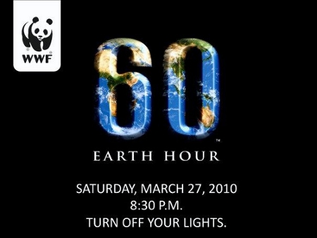
On March 27 at 8:30 pm (local time), millions of people all over the world will be turning off their lights for one hour, in a stand against climate change. Earth hour started om March 31 2007 in Sydney, Australia when 2.2 million people turned off their lights at 7:30 for one hour. Since then Earth hour has grown to more than 100 countries around the globe and over 40 million people participating. Major landmarks such as the Pyramids of Gaza in Cairo, Egypt, Big Ben in London, England and Empire State Building in New York, participate in the event as well by turning off their lights. For more information check out http://www.earthhour.org/Homepage.aspx?intro=no. Together we can make a difference!
Tuesday, March 23, 2010
Cooler Temps and Showers
Area Forecast- Union, NJ
(March 23 to March 28)
This weather this past weekend was a great start to Spring, but with Spring also comes showers and the thunderstorm last night was the first for the area this season and the temperatures this week will be much cooler than last week. For today we can expect a high near 59 and chance for rain in the afternoon as a low pressure system passes over the region. Wind will be slightly breezy from the southwest at 7 mph. For tonight we can expect a chance of rain before 3 am and low near 40. The wind will increase for tonight as the low pressure system passes through creating a strong pressure gradient. Winds will be from the west at 13 to 20 mph. The pressure gradient remains strong as we can expect breezy conditions for Wednesday with west winds at 17 to 23 mph. We can also expect mostly sunny skies and a high near 60. Wednesday night will be mostly clear with a low around 38 and west wind at 10 to 14 mph. For Thursday we can expect mostly sunny skies and a high near 58. A cold front will be moving into the region for Thursday night as we can expect a chance of rain after midnight and a low around 38. The cold front will pass through the region by Friday as we can expect a chance for showers before noon and a high in the mid 40s. Yup that's right I said 40s. Friday night looks to be clear with a low at 29. High pressure will build in the region for Saturday into Sunday as we can expect mostly sunny skies and a high near 48 for Saturday. Temperatures will rebound for Sunday as we can expect sunny skies and a high of 54.
source: NOAA
Tuesday, March 16, 2010
1.26 Milliseconds Shorter

I should have posted this article sooner, it talks about the 8.8 earthquake in Chile possibly slowing down the earth's rotation and therefore slowing the day by 1.26 milliseconds. Though 1.26 milliseconds may not seem like much, it is significant and amazing that an earthquake can slow down the rotation of the earth and put it off its axis. Here is the article:
SPACE.com Staff
SPACE.com Space.com Staff
space.com – Tue Mar 2, 10:00 am ET
SPACE.com Space.com Staff
space.com – Tue Mar 2, 10:00 am ET
The massive 8.8 earthquake that struck Chile may have changed the entire Earth's rotation and shortened the length of days on our planet, a NASA scientist said Monday.
The quake, the seventh strongest earthquake in recorded history, hit Chile Saturday and should have shortened the length of an Earth day by 1.26 milliseconds, according to research scientist Richard Gross at NASA's Jet Propulsion Laboratory in Pasadena, Calif.
"Perhaps more impressive is how much the quake shifted Earth's axis," NASA officials said in a Monday update.
The computer model used by Gross and his colleagues to determine the effects of the Chile earthquake effect also found that it should have moved Earth's figure axis by about 3 inches (8 cm or 27 milliarcseconds).
The Earth's figure axis is not the same as its north-south axis, which it spins around once every day at a speed of about 1,000 mph (1,604 kph).
The figure axis is the axis around which the Earth's mass is balanced. It is offset from the Earth's north-south axis by about 33 feet (10 meters).
Strong earthquakes have altered Earth's days and its axis in the past. The 9.1 Sumatran earthquake in 2004, which set off a deadly tsunami, should have shortened Earth's days by 6.8 microseconds and shifted its axis by about 2.76 inches (7 cm, or 2.32 milliarcseconds).
One Earth day is about 24 hours long. Over the course of a year, the length of a day normally changes gradually by one millisecond. It increases in the winter, when the Earth rotates more slowly, and decreases in the summer, Gross has said in the past.
The Chile earthquake was much smaller than the Sumatran temblor, but its effects on the Earth are larger because of its location. Its epicenter was located in the Earth's mid-latitudes rather than near the equator like the Sumatran event.
The fault responsible for the 2010 Chile quake also slices through Earth at a steeper angle than the Sumatran quake's fault, NASA scientists said.
"This makes the Chile fault more effective in moving Earth's mass vertically and hence more effective in shifting Earth's figure axis," NASA officials said.
Gross said his findings are based on early data available on the Chile earthquake. As more information about its characteristics are revealed, his prediction of its effects will likely change.
The Chile earthquake has killed more than 700 people and caused widespread devastation in the South American country.
Several major telescopes in Chile's Atacama Desert have escaped damage, according to the European Southern Observatory managing them.
A salt-measuring NASA satellite instrument destined to be installed on an Argentinean satellite was also undamaged in the earthquake, JPL officials said.
The Aquarius instrument was in the city of Bariloche, Argentina, where it is being installed in the Satelite de Aplicaciones Cientificas (SAC-D) satellite. The satellite integration facility is about 365 miles (588 km) from the Chile quake's epicenter.
The Aquarius instrument is designed to provide monthly global maps of the ocean's salt concentration in order to track current circulation and its role in climate change.
source
-->
Feeling Like Spring/ Flood Safety Awareness
Area Forecast- Union NJ
March 17 to March 21
March 17 to March 21
We are definitely drying out from the low pressure this past weekend, which brought strong winds and heavy rain to many parts of the area. Atlantic City reported gusts of up to 65 mph on Saturday and almost 6 inches of rain was reported at New Vernon in Morris County. Downed trees, large branches and downed power lines were reported in some areas, as well as flooding and power outages. This week looks to be dry and and a nice transition to Spring as high pressure from our west moves into the region for St. Patrick's Day. We can expect sunny skies and a high near 63. For Thursday we can expect sunny skies and a high near 65. Thursday night a backdoor cold front will be moving into the region as we can expect partly cloudy skies and a high near 42. That cold front will move to the north as a warm front approaches the area on Friday. We can expect mostly sunny skies and a high near 63. High pressure off the coast will move into the region Friday night as we can expect mostly sunny skies and a high near 64 for Saturday (the official start of Spring). Low for Saturday night around 41. For Sunday we can expect partly sunny skies and a high near 60. A cold front approaches slowly from the west as we can expect a slight chance of showers for Sunday night, low around 42.
As I mentioned earlier, flooding was reported in some areas as a result with this past storm. March 15 through the 19th is National Flood Awareness Week. The goal of this week is to educate the public about the dangers of flooding, how they occur, and how to stay safe from this phenomenon. Floods are the number one natural disaster in the United States, and many of flood-related deaths occur in vehicles. It is important to toward around if there is flooded water in front of you, if you are driving or walking. In fact six inches of water is enough to float a car and it can be swept away in 18 to 24 inches of water. More information can be found here. Stay safe!
As I mentioned earlier, flooding was reported in some areas as a result with this past storm. March 15 through the 19th is National Flood Awareness Week. The goal of this week is to educate the public about the dangers of flooding, how they occur, and how to stay safe from this phenomenon. Floods are the number one natural disaster in the United States, and many of flood-related deaths occur in vehicles. It is important to toward around if there is flooded water in front of you, if you are driving or walking. In fact six inches of water is enough to float a car and it can be swept away in 18 to 24 inches of water. More information can be found here. Stay safe!
Tuesday, March 9, 2010
Sun and Showers
March 9 to 14
(Area Forecast-Union, NJ)
Spring is getting closer and the weather yesterday with sunny skies and high temperatures in the lower 60s, definitely is a nice change to snow we'd been recieving the previous weeks. Today will be a repeat of yesterday with sunny skies and a high near 60. High pressure will remain in the area for Wednesday as we can expect partly sunny skies and a high near 54. Winds will be calm at 5 mph. That high will be moving northeast on Thursday as a low pressure from our west moves into the region as we can expect a slight chance of rain after 9 am and a high near 54. By Thursday night the low is more in our area and as we can expect showers after 7 pm. The low will remain in our region Friday through Sunday as we can expect a period of rain throughout the rest of the week and temperatures in the lower 50s.
source: NOAA
Monday, March 1, 2010
Warmer Temps and March snow
(Area Forecast-Union, NJ)
March 2 to March 7
March 2 to March 7
It's March! February went out like a lion (Union, NJ got 12 inches from the snowstorm, a.k.a. "snowicane" that occurred February 25 to the 26) and looks like March will be coming in like a lamb, at least for this week. For Tuesday we can expect mostly cloudy skies and slightly warmer temperatures with the high reaching into the mid 40s. A deep low pressure system of the coast of Cape Cod, will be tracking eastward Tuesday night as we can expect a chance of snow and rain. Though the snow is still on the ground at Kean, last year around this time there was snow on the ground from a system that came through on March 2. I shot a video of the storm which can be found here. From that system a year ago, 5.3 inches of snow accumulated, no accumulation is expected for tomorrow night from this low pressure system. Another low pressure system from the Gulf of Mexico will move northward for Wednesday as we can expect a chance of rain and snow throughout the day and a high near 42. No accumulation is expected with this system as well. That low will then move off to the south east as high pressure from the west moves into the region for Thursday into the rest of the week. We can expect mostly cloudy skies for Thursday and a high near 40. For Friday temperatures will be slightly warmer with a high near 45 and mostly sunny skies. Looks to be a nice weekend for Saturday and Sunday as we can expect temperatures in the upper 40s and partly sunny skies for both days. Spring is almost here (March 20th) and don't forget to turn your clocks ahead one hour, daylight's savings time is March 14th.
Earthquake Could It Happen Here?
On February 27th, an 8.8 magnitude occurred off the coast of the Maule Region of Chile causing much devastation and loss of life to the region. Tsunami warnings where issued for 53 countries in the Pacific Basin and the earthquake, which lasted only three minutes, was said to be 500 times greater than the earthquake that struck Haiti back in January and over 90 aftershocks where felt after the earthquake. Just a day earlier, a 7.0 magnitude occurred off the coast of the Ryukyu Islands in Japan. No damage was reported nor was there a threat for a tsunami. With the recent major earthquakes I just wanted to share an article I wrote that was printed in my school's newsletter, The Cougar's Byte, on February 2nd. The article is addressing the possibility of an earthquake such as the one the stuck Haiti, occurring at Kean University, my school which is located in Union, NJ (Northern, NJ). Though the possible of earthquake of that magnitude or a magnitude of the earthquakes that recently occurred is very unlikely, earthquakes occurring near the area are possible. In fact, on February 21st, a 2.6 magnitude earthquake rattled several areas of Somerset County, which is located in Northern, NJ and west of Union County. Though you may not live in an area where earthquakes are likely to occur, it is still good to know the procedures in case you or someone you know is in an earthquake. Knowing can save lives.
Here is the article printed February 2nd:
With the recent earthquake that struck Haiti on Tuesday, January 12, 2010, some students and faculty members at Kean University may wonder if such an event could ever occur on or around campus. The truth is that although an earthquake of the same magnitude which struck Haiti is not as likely to occur, the event of an earthquake happening near this region is possible. Earthquakes occur every day in different regions of the world. These earthquakes are monitored by the U.S. Geological Survey, or USGS, and although most of the magnitudes of these earthquakes are lower than 3.0 and cause little or no damage to the area, some such as the 7.0 earthquake that struck Haiti, are very significant and can cause great loss and structural damage.
So what really classifies as an earthquake? When the surface of the Earth rolls, shakes, or a sudden shock is felt, the movement is identified as an earthquake. Though some may include the shaking felt when the train at Union Station moves past on the tracks to be considered as some form of an earthquake, the actual "quake" in earthquake is normally caused by the movement of the tectonic plates or fault lines, shifting or breaking, below the surface of the earth or underground trembling caused by volcanic forces. There are 20 tectonic plates around the world and everyday these plates move slowly past one another. As they move, force is placed on the plates and when this force becomes too great, the crust breaks and the stress is released in a trembling in the form of waves underneath the ground and can be felt for the region where or around where the break occurred. Faults, such as the Enriquillo-Plaintain Garden Fault System that caused the earthquake in Haiti, are fractures that can be as small as millimeters or as large as kilometers in length and the fractures are between two types of rock or blocks. When the movement between the faults is quick, the resulting release of stress causes earthquakes to occur. A well known fault system in New Jersey is the Ramapo Fault, which is also seen as a threat to New York.
The Ramapo Fault is located much further north of the Kean University area and there are no fault lines around Kean University. Recently, three cases of seismic activity occurred in Morris County along the Ramapo Fault, in the first three weeks of February last year. These quakes were however, minimal and measured less than 3.0 on the Richter Scale causing little to no damage.
In knowing about the occurrence of earthquakes, safety is important. It is best to have a plan of action as well as an emergency safety kit, in case of an earthquake. If it happens while indoors, go under a sturdy piece of furniture. Do not go outside until shaking stops. If it happens outside, find a spot away from power lines, trees or buildings, drop to the ground, and take cover. If driving, slow down and stop on the side of the road, avoiding bridges, overpasses, and large signs, and remain in the car. After the quake, expect aftershocks, also check for injuries and damage; and if there is no electricity, unplug major appliances to prevent possible damage when the electricity returns. For more information and safety tips about earthquakes, visit the U.S. Geological Survey website at http://earthquake.usgs.gov/earthquakes/.
Link here
Friday, February 26, 2010
El Nino 2009-2010/ Snow Cover
It has definitely been a very snowy winter this season, and the Nor'Easter today has broken some records in some parts of the Northern Atlantic States (i.e. 114-Year Old Snowfall Record Broken For NYC Central Park.) Why so much snow? The El Nino pattern that we've been in since December 2009 has much to do with the recent occurrences of the white stuff. Typically in an El Nino pattern, more warm areas are found in Southern Canada as cold snowy weather can be found in the east and south east. Forecasters predicted that the El Nino would strengthen as the winter progressed and an indicator of this has been the colder temperatures found in parts of Florida and the south east. El Ninos usually occur every four to five years, in fact the last occurring from December 2006 to February 2007. Below is a visual representation of the El Nino weather phenomenon as well as the La Nina weather phenomenon:

All this snow has covered much of the Northern Hemisphere and according the the NOAA's National Operational Hydrologic Remote Sensing Center (NOHSRC), 52.4% of North America is covered by snow or ice. It's not nearly as close as the analysis a month ago, in which 69.7% of North America was covered. This analysis shows that there has been much snow melt, but with much of the snow melting there has been flooding in some areas. Is it just me or does the map from a month ago look very reminiscent to the map at the end of the Day After Tomorrow? Hmmm....
 February 26, 2010
 January 31, 2010
Saturday, February 20, 2010
More Snow Our Way?
(Area Forecast- February 21- February 27)
Union, NJ
Union, NJ
I know some of us may be tired of the snow, but looks like we may be seeing snow showers later week, for Monday night into Tuesday morning. For Sunday we can expect sunny skies and a high near 47 as a high pressure system from our west will move into the region. It will be slightly windy with west winds at 11 to 16 mph with wind gusts up to 26 mph. That high pressure will be moving to the east and a low pressure system from our west will move into the region Monday night. We can expect a chance for rain shower showers after 3 pm, and a high near 46 for Monday. Rain and snow is expected for Monday night as it will be cloudy with a low around 31. Not much is expected with this system with new precipitation amounts near a quarter to an inch possible. As that low moves to the north, a secondary low from the south will bring us a rain/snow mix for Tuesday as we can expect snow before 9 am, then rain and then a change back over to snow, between 9 am to noon. High expected near 37. For Tuesday night that low will move off the coast as we can expect a slight chance of rain and a low around 33. The low will linger over New England for Wednesday through Saturday as we can expect mostly cloudy skies for Wednesday into Thursday and temperatures in the upper 30s. Chance of snow showers is possible for Wednesday into Thursday morning. Temperatures will dip into the lower 30s Friday into Saturday as we can expect mostly cloudy and chance of snow showers for both days as well. Looks like we'll be drying out for Sunday as we can expect sunny skies and a high near 40.
Wednesday, February 17, 2010
Snow Snow Go Away
Hi everyone!
I am still here, I have taken a LONG hiatus, by not updating this site since Dec 19th of last year. The wait is over, I am back and ready to update you with more information about weather phenomena and other Earth Science related topics. Weather is my passion and I'm sorry I have not been on here to update this site. I've been working hard towards graduating, it's coming this Summer!
So what about all this snow? Well with yesterday's clipper system and the perfect set up for a major snow storm the previous two weeks, I know many people along the Northeast are wishing they lived some place warmer. I myself and growing tired of the snow. It seems like it's been a while since parts of South Jersey received significant amounts of snow and in the DC area and some parts of Maryland and Pennsylvania, received record amounts of snow. This winter has definitely been a snowy one and it's not over yet. No I'm not going by the groundhog's prediction, (doesn't he always see his shadow), I'm going by the official start of Spring and that isn't until March 20th. Even then there is still, though unlikely chance of snow. Snow snow go away and bring some warmer temperatures. Though in many areas around the region, melting of the snow brought on by the increasing daytime temperatures, may result in flooding for the area, which in some cases creates more of a problem than the snow itself. Stay tuned for a later update on the weather for this week. It feels great to be back!
Subscribe to:
Posts (Atom)